Professional
Treefall Risk Project
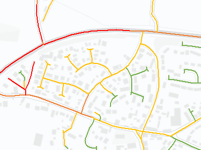
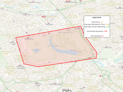
This project aimed to try and identify roads at the highest risk of experiencing a damaging treefall event so that surveying resources could be focussed in order to maximise their effectiveness. By focussing resources, treefall events caused by an ongoing disease epidemic could be minimised to potentially save lives, repair costs and council reputation.
GIS datasets were combined from disparate sources and aggregated to road level to indicate the likelihood of a treefall event occurring on a particular road segment along with the potential magnitude of damage if one was to occur. From this, a final risk matrix was made with all roads categorised into one of the matrix segments. These segments were then assigned a survey type, with roads at higher risk being assigned the most thorough survey and those at lower risks being surveyed less thoroughly.
Read more...
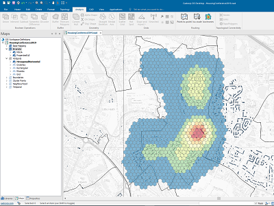
Gully Sensor Project
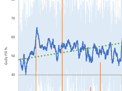
This long-term project involved installing sensors into gullies within a local authority's drainage network to determine their suitability in providing real-time fill level data for use with flood warning systems and cyclical cleanse decision-making.
The project required the risk-modelling of gullies within the network to determine locations that would most benefit from sensor installation. Several datasets were combined and analysed to determine a final list of sensors for installation.
Six months worth of data was collected and analysed to determine several distinct gully profiles displayed along with a list of characteristics required in a gully for successful sensor installation.
Read more...
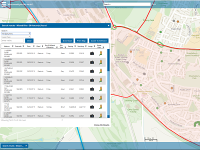
Splitting Grass Verges Task
A client asked for a dataset of grass verges within their county segmented according to the road classification (A/B/C/Unclassified) that it was nearest to, so that they could focus grass cutting resources.
The initial grass verge data was obtained from OS Mastermap Topo, then Thiessen polygons were created from road centreline data containing the road classification information. The Thiessen polygons were then dissolved and used to segment the grass verges according to the road type they were nearest to.
Read more...
Winter Programme Project
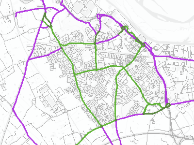
This large-scale project involved the creation of a combined winter services plan for three neighbouring local authorities that had previously worked separately. Resources were to be shared on a new set of cross-border salting routes in order to minimise fuel and CO2 costs.
The existing data from each authority was collated and recreated in a cohesive format, before being analysed to highlight potential changes at authority boundaries where coverage could be improved. Strategic locations were determined in each area and associated roads were added to the routed network. Roads were then re-classified into primary or secondary importance before several routing algorithms were utilised to create 42 new salting routes covering both primary and primary/secondary combined roads
The optimised routes created were found to potentially save the authorities around £3500 in fuel costs and around 6500kg of CO2 per annum when primary routes alone are salted.
Read more...
M-Files Digital Workplace Conference 24 & 25/09/2019

This conference was hosted by M-Files, a Cadcorp partner that has integrated the Cadcorp Web Map system within their Intelligent Information Management platform. It took place at Mercedes-Benz World in Weybridge, Surrey. For the conference, I gave two presentations, one on each day.
The first day’s presentation was entitled ‘The Power of Integrations: Why Your Existing Systems Should Talk to Each Other’
The second day’s presentation was entitled ‘Partnering With M-Files. What Is It Really Like?’
Read more...
Cadcorp Emergency Services Conference 10/10/2019
This conference was hosted by Cadcorp and the delegates came from a range of existing and potential customers in the Emergency Services sector, with attendees from Fire, Police and NHS services present. It took place at Manchester Central Conference Hall in Manchester.
My presentation was entitled ‘SIS Web Map: Top Rated Features’ and involved me doing a live demonstration of some of the new features of the latest release of Cadcorp’s Web Map software that were particularly relevant to emergency services customers.
Read more...
Cadcorp Housing Conference 14 & 21/05/2019
These conferences were hosted by Cadcorp and the delegates came from a range of existing and potential customers in the Housing sector, with attendees predominantly from social housing associations. The conferences took place at the DoubleTree by Hilton in Leeds on the 14th of May, then at the Congress Centre on Great Russell Street, London on the 21st May. I gave two presentations at each conference.
The first presentation was entitled ‘The Importance of Web Mapping and GIS’ and covered the very basics of why GIS can be so beneficial to housing associations.
The second presentation was entitled ‘SIS Desktop: Top Rated Features’ and involved me doing a live demonstration of the new features in Cadcorp’s Desktop GIS solution, with particular focus on the features that are most beneficial for housing customers.
Read more...
Cadcorp Local Government Conference 12 & 19/03/2019
This conference was hosted by Cadcorp and the delegates came from a range of existing and potential customers in the Local Government sector, with attendees from authorities across the UK present. The conferences took place at the Congress Centre on Great Russell Street, London on the 12th March, then at the DoubleTree by Hilton in Manchester on the 19th March.
My presentation was entitled ‘SIS Web Map: Top Rated Features’ and involved me doing a live demonstration of some of the new features of the latest release of Cadcorp’s Web Map software that were particularly relevant to local government customers.
Read more...
Curricular
Postgraduate Dissertation: Understanding a burglar’s target selection process through the adaptation of an agent-based burglary model using recent qualitative research
For my postgraduate dissertation, I undertook work looking into the area of predictive policing; specifically, the use of Agent-Based Models to simulate spatial patterns of burglary. By adapting an existing model using findings from interview-based research into a burglar’s target selection process, I was able to analyse how certain behavioural traits described by interviewees impacted the predictive capability of the model.
Results showed that each model created was able to improve upon some aspect of the initial model, however none could consistently return more accurate burglary patterns across all methods of analysis. However, evidence was found to suggest that the accuracy of the model’s predictive capability may be improved through the implementation of agent morality, opportunistic behaviour and interpersonal motivation.
Read more...
Creating an interactive website giving information about the time zones of the world
This assignment required that I create a website with a significant mapping component displaying the spatial distribution of a geographical phenomenon. I chose to create an interactive website showing the location of the Time Zones of the world and information about each one.
The site was created using HTML, CSS, JavaScript and PHP, with significant mapping components being created using Leaflet.js.
Read more...
Investigating the reasoning behind the catastrophic flood in Boscastle in 2004
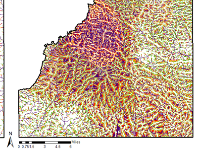
For this project, I studied the causes of the flooding in Boscastle, Cornwall in 2004 in order to suggest future action that could be taken to avoid such an even from occurring again. Flood maps were created from rainfall data on the day and water flow was modelled in the area to assess the severity of the weather event.
Findings suggested that the extremity of the weather had the largest impact on the severity of the flooding. However, it was further exacerbated by the topology and land use of the drainage basin. Locations for natural flood management measures were suggested for the affected area.
Read more...
Investigating the link between proximity to motorways and levels of Limiting Long-Term Illness (LLTIs)
This project used GIS techniques analysed whether the use of a potentially toxic colourant in motorway signs was causing an increase in the number of Limiting Long-Term Illnesses in those that reside near to motorways. Analysis was performed in ArcGIS using boundary and Census data from CASWEB which was cleaned and apportioned according to a 5km motorway buffer.
No proof could be found to link proximity to motorway and prevalence of LLTI within the study area, with the levels of inner-city deprivation seeming to be a bigger factor.
Read more...
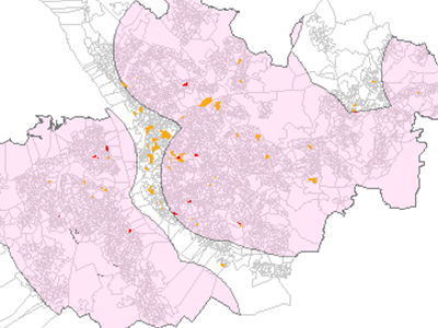
Examining the different techniques for spatial analysis of point data using burglaries in the West Yorkshire area
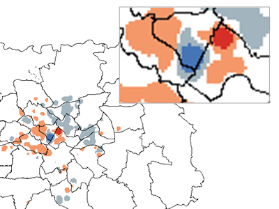
This report assessed various spatial techniques for suitability in representing a point dataset of burglary, with both point and polygon methods being studied.
The point level methods were Openshaw’s GAM method and Kernel Density analysis to create a surface of clustering across the study area. Upon aggregation of the dataset to polygon level, the Getis Ord Gi* statistic could be mapped, as was the Anselin Local Moran’s I value to highlight regions of value clustering and outlying polygons. Temporal mapping was also studied using the Kernel Density method.
Read more...
Creating an Agent-Based Model of Hammond's model of social inequality using NetLogo
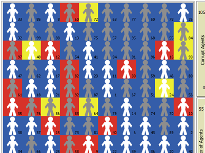
This project used NetLogo to implement a version of Hammond’s model of social corruption. It contains citizen and bureaucrat agents that can act in an honest or corrupt way depending on their surroundings and experiences. Each agent balances risk and reward, with corrupt agents potentially receiving greater payoffs for transactions but risking jail time.
Under default conditions agents begin by being generally corrupt, however after a certain tipping point, society reverts to honesty for the duration of the model run. The model is fully adjustable so that users can observe how changing each setting impacts the society.
Read more...
Undergraduate Dissertation: Combatting the de-skilling of modern drivers through the development of an implicit in-car navigation system
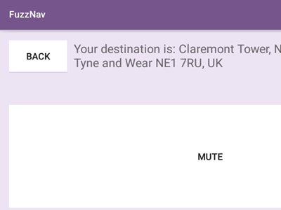
This dissertation looked into the problems modern drivers face in not developing basic navigational skills due to a reliance on instruction-based satellite navigation systems. I developed an alternative system, FuzzNav, that used implicit audio instructions to guide the driver towards their destination without explicitly telling them which route to take. The system was created as an Android application using the Java language.
Final user testing using volunteer drivers gave proof that the implicit system required better navigational skills to use, as well as allowing for greater driver interaction with the surroundings. However, issues were raised regarding the safety of using such a system and no long-term testing was performed to assess skill development; areas of potential future work.